NUNNVILLE - One Man's Dream
( A GHOST TOWN )
By Jerry Gorman 2015
Revised February 2018
The Journey To Albion
The earliest settlers to Albion Township had a long, arduous journey ahead, as they departed Toronto to take up land for farming. To reach Albion Township they travelling north on Yonge Street, a muddy trail hacked out of the bush in 1796 , then diverted west to follow the even more rugged King Road. Facing even more difficult terrain, King Road ended abruptly at the boundary between Albion and King Townships where an alternate route was developed to avoid the long, steep hill ahead. Instead they followed the Township boundary road south before again diverting west. Here they found more agreeable route following the valley floor on south side of the Humber River. Now called Old King Road, it reconnected with the King Road on the east side of Bolton. The original right of way that completed King Street East into Bolton was finally built one hundred years later in 1950.
Settlers making their way to Albion Township from the Town of York (Toronto) after 1820, started their journey at Yonge Street, a muddy military trail built in 1796.
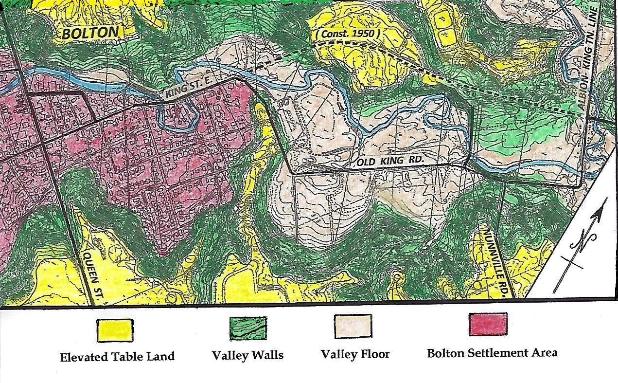
Map Emphasizing Landforms In The Bolton - Nunnville Area
NUNNVILLE
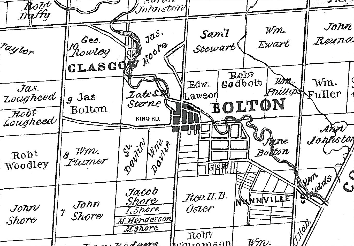
The survey that opened up Albion Township for settlement was completed by James Chewett in 1819. This map shows the village of Bolton and area in 1859, at a time when the local farmers were thriving and the population of Bolton was growing rapidly. The hamlet of Bolton's Mill, established by George Bolton in 1822, is emphasized below in black at the intersection of King and Queen Streets. The 100 acre farm lot purchased by Henry Nunn in 1825 , Lot 8, Concession 7, was laid out for sale as building lots in 1854 and named Nunnville. Ambitious plans of subdivision for Bolton, Glasgow and Nunnville were indicative of the optimism for growth that was anticipated.
REAL ESTATE BOOM
Between 1841 and 1851 the population of Albion more than doubled, fuelled by the demand for local grain, exported to Europe during the Crimean War ( 1853 – 1856 ) and the American Civil War ( 1861-1865 ). In 1854 Thomas Prosser, the local land surveyor was contracted to draw up street plans and building lots for the expansion of the Bolton and a new real estate venture by Henry Nunn. Between 1852 and 1855 land speculation sales boomed. James H. Bolton stated in Bolton: Some History and Events, "Speculators got a kick out of buying and selling the lots in the Village of Nunnville, a suburb east of the Village of Bolton." No buildings were erected. The map, "Plan of Bolton and Plan of Nunnville," shows that lots in Nunnville were unusually large when compared to those in Bolton. They were designated "Park Lots."
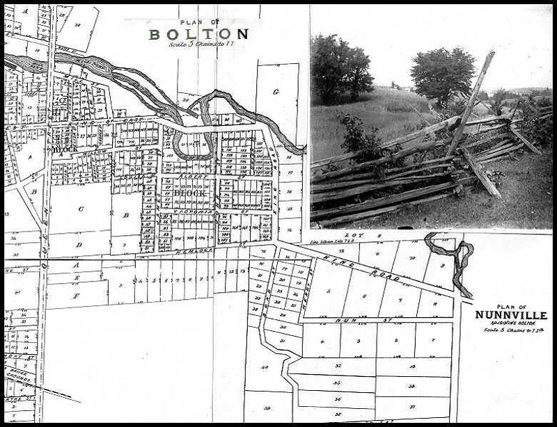
"Nearly all lots were fenced with split cedar rails, waiting for buyers "
Check here to see the subdivision and Google overlay context map
End Of A Land Speculators Dream
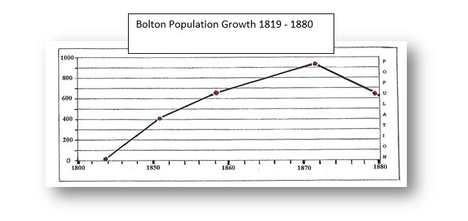
Demand for local grain exports declined drastically after the wars in Europe and the United States ended. The final blow came with the Canadian Government's Dominion Land Act of 1872. With 160 acres of free land available to anyone willing to settle in Western Canada, young men left Albion to take up prairie farming and immigrants bypassed Albion on their way west. With the decline in population, Henry's dream evaporated and this land became summer pasture for local cattle farmers. After peaking at slightly over 900 in 1877 Bolton continued to lose population. In 1939 it was recorded as 530. Not until the 1960's did a resurgence in growth occur.
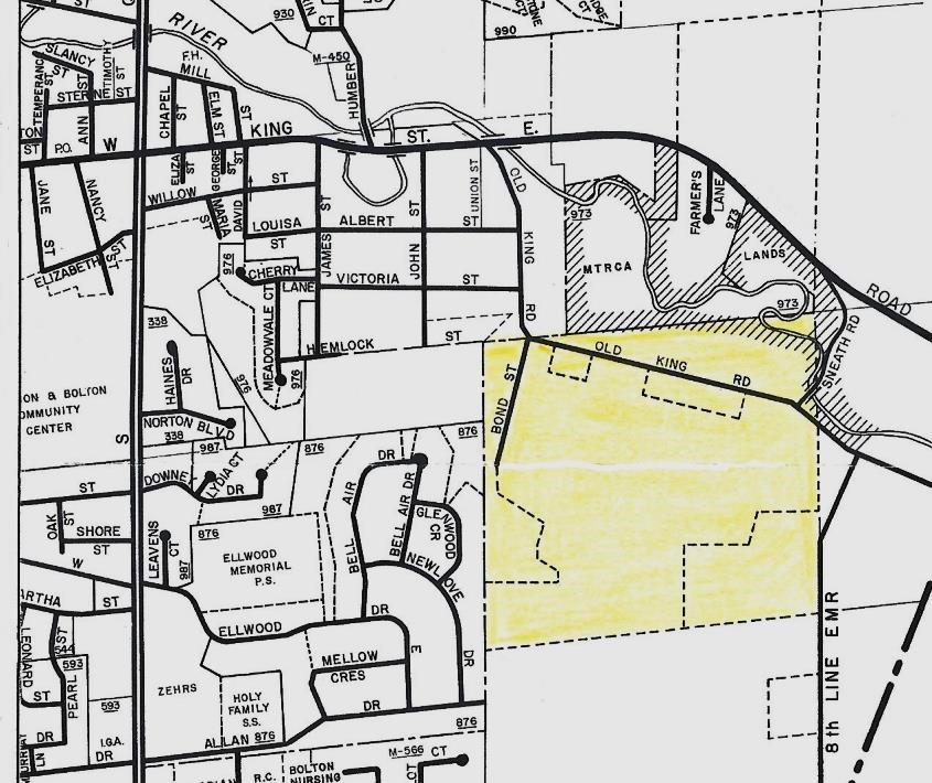
This Bolton Street Map shows Henry Nunn's tract in light yellow, still undeveloped in 1974. The only reminder of Nunnville's existence is the 8th Concession Line named Nunnville Road.
THE HENRY NUNN FAMILY
Both Henry and Maria Bolton were born in England and married after they met in Upper Canada. Maria was the daughter of James Bolton, a relative of George Bolton the founder of Bolton's Mill. They were among the earliest settlers who made the long journey over the primitive roads to claim their land, immediately after Albion Township was opened for settlement. Henry was a trustee for the Primitive Methodist cemetery located at Tormore, Regional Road 50 at Mayfield Road. He was also a political activist, who along with his neighbours James and George Bolton, signed the local petition in 1833 in support of William Lyon Mackenzie, leader of the Upper Canada Rebellion. James and his son Samuel had to flee to the USA after the rebellion for the active part he played in it. Samuel returned in 1849. Henry was not implicated.
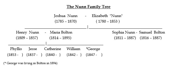
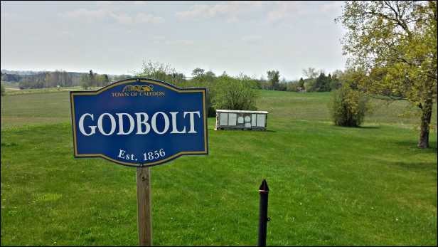
While Henry is Buried in the Godbolt Primitive Methodist Cemetery on the Caledon King Town Line 4.5 Km North of Bolton, Maria was interred in Laurel Hill Cemetery in Bolton.
WHAT'S IN A NAME
The 8TH Concession was an active route for farmers taking grain to Bolton 's mill and for political activists meeting in Bolton and Lloydtown during the lead up to the Rebellion of Upper Canada. Pioneer road building is still evident north of Sneath Rd. where a side trail from the Humber Valley Heritage Trail traverses the former Bolton Camp Property. This section of the rugged road right of way was eventually abandoned.
Nunnville Road is that short section of the 8th Concession Line going uphill north of Old King Rd. and connecting it to the Albion Vaughan Town Line road.
Sneath Road was that short portion of the 8th Concession Line between Old King Road and King Street East, that took its name from James Sneath. He was a local land surveyor who worked in the Bolton area from the 1950's to the mid 1970's. His home was located at the top end of Sneath Road. William Shields was a notable early resident who arrived in 1858. His scenic lot was located on the north east side of the bridge and sloped down to the Humber River. The Shields family grew in prosperity from their very successful store in Bolton. The family name became widely known after 1898 when William's estate endowed the Toronto General Hospital with sufficient money to support an Emergency Wing. His house was designated a Heritage Property by the Town of Caledon.
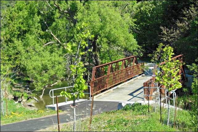
Sneath Bridge
Road Bridge 1915 - 2008
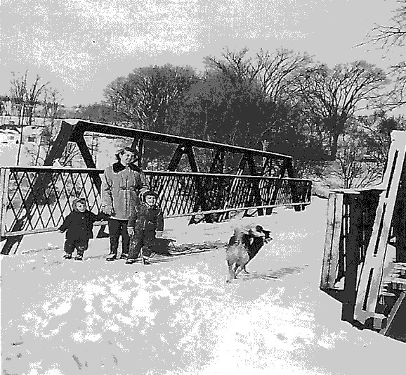
Pedestrian Trail Bridge 2014
Some More Recent History
The Mayor of Nunnville – quoting James Bolton in his publication Some History and Events, "Old Jack Wilson, something of a character, was the last resident of the district and was known affectionately by this title. He lived in a small house at the end of Bond Street, the site of the Bolton village dump in 1930's. The Nunnville dump was closed in 1960.
Extension of King St. East - The Humber River was finally bridged where Old King Road met King Street East and the road extended into King Township in 1950.
"Sunkist Valley" was an name created to promote real estate in the Nunnville area shortly after the extension of King Street East. It was not until 1995 that the Deer Hollow Road - Sunkist Drive subdivision was built on the land first subdivided for development in 1854.
Sneath Bridge - The current bridge dates back to 1915. It was closed to vehicular traffic in 2008 and refurbished for pedestrian use only in 2014 and is a designated Heritage Bridge. It is thought by some to have been the site of a skirmish prior to the Rebellion of 1837, provoked by perceived favoritism and injustices by the Colonial Government of Upper Canada.
The Humber Valley Heritage Trail - Nunnville became part of the original trail in 1996. In 2014 the bridge location became the trail head to a new 2 km. loop trail through the former Bolton Camp following Sneath Road, crossing King Street East and proceeding uphill along the original 8th Concession line pioneer road into the old Bolton Camp.
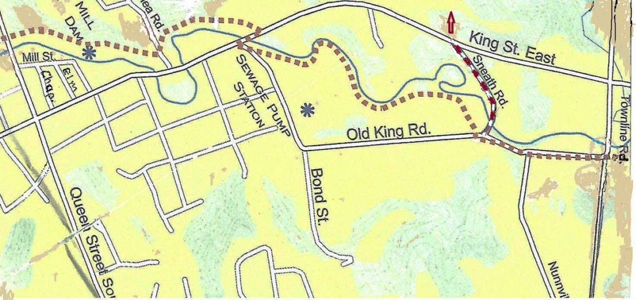
THE NUNNVILLE TRAIL HEAD
Access to the Bolton Camp Loop Trail
Click here to view the larger map